The results are in from the world’s biggest river expedition
Final conclusions from the Joint Danube Survey 2 will improve the ability of Danube country leaders to decide on what measures still need be taken to meet EU laws and implement the Danube River Protection Convention.

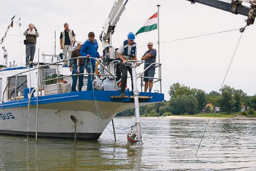
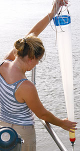
The three JDS2 boats – the Argus, Széchenyi and Vienna 115 (chartered by the EC’s Joint Research Centre in Ispra, Italy, to assess fish fauna) – travelled 2,415 km down the Danube River, through ten countries, to the Danube Delta. Water, sediment, biology, suspended solids, mussels and fish were sampled, with some testing taking place on board the ships.
The Joint Danube Survey 2, also known as the ‘JDS2’, was the world’s biggest river research expedition in 2007. Its main goal is to produce highly comparable and reliable information on water quality and pollution for the entire Danube River and many of its tributaries. The information is also essential for the Danube countries and the ICPDR to attain an overview of the water quality needed to meet the requirements of the eU water framework Directive (wfD) by 201 . The ICPDR coordinates overall JDS2 implementation. The first JDS was held in 2001.
The JDS2 was officially launched on August 14, 2007 in Regensburg, Germany. In total, a distance of 2,600 km of the Danube River was assessed, 2,415 km of which were completed by the three boats of the JDS2 travelling from Kelheim, Germany, through 10 countries, to the Danube Delta in Romania and Ukraine until late September. Along the Danube River, 96 sites were sampled, as well as 28 sites on its major tributaries. The JDS2 gathered comprehensive scientific information, strengthened basin-wide cooperation among the scientific community and increased public awareness toward water quality protection.
Since the expedition’s end, scientists and laboratories across Europe have been busy testing samples, compiling data, exchanging information and developing final reports, all coordinated by the ICPDR. The preliminary final results are now out. Here are some of the main highlights.
 The international scientific
team travelling the
entire Danube included
18 scientists, and teams
of national scientists were
also a big help on river
stretches within their
countries.
The international scientific
team travelling the
entire Danube included
18 scientists, and teams
of national scientists were
also a big help on river
stretches within their
countries.Hydromorphology. The assessment of the ‘hydromorphology’ of the Danube was a completely new task. It was prepared because the WFD requires EU river systems to have a ‘good ecological status’ by 2015, and because good water quality alone is not sufficient to pass the EU test. ‘Hydromorphology’, as defined by the WFD, is the physical characteristics of the shape, the boundaries and the content of a water body. To have good ecology, the Danube and its tributaries must, for example, serve as habitat for characteristic animals and plants, and therefore provide typical structures required for such habitat.
Overall, the assessment showed that the Lower Danube is in better condition than the Upper part, and that about 40% of the investigated Danube is in good condition, meaning that there are still many healthy ecological areas – a status that is generally more positive than earlier perceived.
Biology. The analysis of macroinvertebrates (aquatic insects, worms, clams, snails and other animals without backbones that can be determined without the aid of a microscope and that live in or on sediments) indicated good biological water quality for almost 80% of the Danube sites. Significant organic pollution affecting living organisms was detected in the tributaries Sio, Jantra and Rusenski Lom. Due to excessive pollution, the Arges River did not host any macroinvertebrates.
The fish survey, the first ever for the Danube, revealed that only about one-third of the investigated sites on the Danube indicated good status. Hydromorphological alterations are the main pressure on fish populations in the Upper Danube, while water quality is a key pressure in the Middle and Lower Danube. The lack of migratory species in the Danube indicates a loss of river connectivity.
In the regulated, non-impounded stretches of the
Danube, macrophytes (plants, either free-floating or
attached to a surface, that can be determined without
the need for a microscope) often meet the conditions
for good ecological status. However, the situation is
unsatisfactory in the impounded stretches upstream
from hydro-electric power plants.
Phytobenthos (microscopic plants such as algae that live in the surface layers of the river), in contrast to aquatic fauna, react directly to the nutrient content (mostly phosphorus) in the river, and are considered to be a long-term reliable indicator of eutrophication processes. The indication of ecological status, based on the phytobenthos analysis, suggested an increase of nutrients in the longitudinal profile of the Danube.
The analysis of phytoplankton (plants, mainly microscopic, existing in water bodies) found most of the Danube with acceptable conditions. Elevated levels of chlorophyll-a (an indicator of phytoplankton) and phytoplankton biomass were found only in the Middle reach.

One-third of the sites were affected by microbial contamination, while faecal indicators (excreted by humans and warm-blooded animals) originated mainly from human sewage. Identified hot-spots were the Danube stretch between Budapest and Belgrade and the tributaries Arges and Rusenski Lom.
Chemistry. The chemical analysis revealed a significantly decreasing profile of nitrate concentrations moving downstream along the Danube. A comparison with the JDS1 results of 2001 revealed higher concentrations of nitrates and mostly lower concentrations of orthophosphates.
Among the EU’s Priority Substances (the EU has 33 substances or groups of substances which have been shown to be of major concern for European waters, including priority hazardous substances), di-(2-ethylhexyl)-phthalate (DEHP) was found in nearly all JDS2 water samples at relatively high concentrations; in 44% of the water samples, the proposed environmental quality standard (commonly agreed concentration levels that are acceptable for “good quality” under the WFD) was exceeded. At several sites, an indication of WFD non-compliance was found for polycyclic aromatic hydrocarbons, nonylphenol, tributyltin and trichlorobenzene. The concentrations of metals in water were found above the quality targets at only three sites. In general, the average concentrations of priority substances detected during the JDS2 tend to be lower than those measured during the JDS1, especially for organic substances.
The results of the ecotoxicological analysis of Danube sediment showed no significant toxic effects.
The regional distribution of 137Cs contamination mainly originated from the Chernobyl accident in May 1986. The JDS2 results demonstrate a clear general decrease by a factor of 10 in the 137Cs activity concentration of Danube sediments between 1988 and 2007. Due to the decreased artificial radioactivity levels in the Danube River, there are therefore no associated health risks. Naturally occurring radionuclides such as 226Ra and 228Ra in the Danube and tributary sediments were found in normal geochemical activity concentration levels. No enhanced anthropogenic input from industrial sources could be detected.

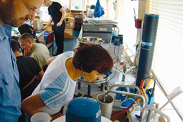
Work on board the Argus often lasted all day and into the night – processing samples to be sent for analyses to onland laboratories, carrying out on-board analyses and preparing and labelling hundreds of bottles, flasks and other vessels.
Overall conclusions and suggested actions. The JDS2 created the most comprehensive and homogeneous database on the status of the aquatic ecosystem of the Danube and its major tributaries. The survey confirmed earlier ICPDR conclusions of a generally improving trend along the main Danube River. It also reinforced specific problems, especially at a number of tributaries and downstream large cities.
The public’s main interest in the JDS2 conclusions is
expected to focus on four main questions:
1. Can people swim in the Danube Basin?
Yes, but not everywhere.
2. Can people eat fish from the basin without
a health risk? Yes, but further investigation of
mercury concentrations is needed in some areas.
3. Is water quality improving? Yes.
For the fourth question – 4.
What still needs to be done? – the JDS2 identified the need
for actions to address: hydromorphology
(e.g. reconnecting
side-arms); continuing the
building and expansion of sewage
treatment plants; specific
industrial pollution problems
(e.g. hot-spots); more intensive
investigations and measures on
some tributaries; and invasive
species.
Finally, more dialogue is needed with major water users in the basin. And the JDS2 data should be made available for future research efforts and dialogue with different stakeholders and users.
The Final Scientific Report and a Public Brochure are expected to be launched in early autumn 2008. For more information, please visit: www.icpdr.org/jds/ or see the story on JDS2 in Danube Watch 3/2007.
The ICPDR would like to express appreciation to more than a hundred Danube water experts contributing to the success of JDS2.
Disclaimer
The information contained in the ICPDR website is intended to enhance public access to information about the ICPDR and the Danube River. The information is correct to the best of the knowledge of the ICPDR Secretariat. If errors are brought to our attention we will try to correct them.
The ICPDR, expert group members, nor other parties involved in preparation of information contained on this website cannot, however, be held responsible for the correctness and validity of the data and information provided, nor accept responsibility or liability for damages or losses arising directly or indirectly from the use of the information conveyed therein.
Only those documents clearly marked ICPDR documents reflect the position of the ICPDR.
Any links to other websites are provided for your convenience only. The ICPDR does not accept any responsibility for the accuracy, availability, or appropriateness to the user's purposes, of any information or services on any other website.
When using the information and material provided on this website, credit should be given to the ICPDR.
