Transboundary cooperation brings the Sava Commission closer to its goals
The first meeting of the river basin commission puts four countries well on their path towards establishing sustainable water management and an international navigation regime on the Sava and its tributaries.

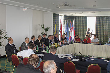
The first meeting of the parties to the FASRB was held in Zagreb to discuss coordination of transboundary cooperation in the Sava River Basin and to develop the Sava River Basin Management Plan.
The first meeting of the Sava River Basin Commission was held in Zagreb, Croatia on June 1, 2007. The International Sava River Basin Commission was established in 2005 to implement the Framework Agreement on the Sava River Basin (FAS RB), signed by Bosnia and Herzegovina, Croatia, Serbia and Slovenia. The main goal of the commission is to coordinate transboundary cooperation in the Sava River Basin.
At the meeting, the parties adopted the report on the work of the Sava Commission from 2004 to 2007, the Methodology of Permanent Monitoring of Implementation of the FASRB and the Declaration of the First Meeting of the Parties.
Strategising for water management. The Sava Commission is currently working on developing the Sava River Basin Management Plan as well as developing the strategy to implement the FASRB, establishing the Sava Information System, creating additional protocols to the FASRB and preparing a set of rules and other documents related to navigation. “The FASRB plays a significant role in implementation of the EU Water Framework Directive”, said Andrej Vizjak, Minister of Economy for Slovenia, “whilst planning the development in the Sava River Basin as the richest water area in the Danube Basin.”
The Sava Commission will meet at least once every two years to review the work and actions of the Sava Commission, make decisions based on proposals and recommendations of the Sava Commission, consider and adopt proposals of new protocols and amendments to the FASRB, and consider and undertake any additional actions that may be required for fulfilment of purposes of the FASRB. This first meeting was, according to Kemal Karkin, Chairman of the Sava Commission, “a good incentive for the Sava Commission and the Parties to the FASRB in further realisation of goals of the FASRB”. The next meeting of the parties will be held in Belgrade in 2009.
Reaffirming commitment. The Declaration
of the First Meeting of
the Parties, adopted at
the meeting, stresses the
liabilities of the Parties
and the Sava Commission
and provides directions for future work. Božo
Ljubić, Minister of Communications and Transport
for Bosnia and Herzegovina, expressed support for the
declaration, saying that it “reaffirms the commitment
of the Sava countries to the FASRB, and, hereby, the
achievement of goals in the field of navigation”.
For more information, please visit:
www.savacommission.org.
MULTI-PURPOSE CANAL DANUBE-SAVA

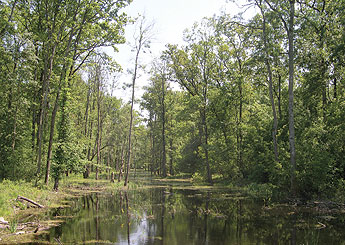
The Spacva Forest in the Sava wetlands is one of the areas that will be affected by construction of the canal.
The Croatian Ministry of Environmental Protection, Physical Planning and Construction (MoE) published the Physical Plan for the Multi-Purpose Canal Danube-Sava in March 2007 and the public hearing was closed on June 11, 2007. Although construction of the canal is planned for 2010, there is a great lobby – including Bozidar Kalmeta, Minister of the Sea, Tourism, Transport and Development, which is responsible for the canal – pushing to begin construction measures in 2007 in order to use 100,000 m3 of excavated material to build the traffic corridor.
Euronatur participated in the public hearing and sent written comments on the project’s main problems to both responsible counties in Slavonski Brod and Vukovar, and a letter was addressed to all members of Parliament. The key problem concerning the protection of the Danube is the plan to drain the largest complex of oak forests, the Spacva-Bosut Depression, to improve agricultural use. Besides the central Sava Basin, the area is the largest retention area along the Sava and is shared by Croatia and Serbia.
Although the physical plan was prepared for the overall canal, the maps and the assessments only show the 61-km-long corridor for navigation (10,600 ha). In all other documents on the canal, the size of the project area is at least 20 times larger and includes three other functions – irrigation, enrichment of low discharges, surface drainage (173,000 ha) and drainage of arable land (62,000 ha). Therefore, the maps and the assessment prepared by the MoE do not show the entire extent of the project. Euronatur asked the MoE to include the planned drainage facilities, such as canals and sluices, in the physical plan as they are a part of the canal. Flood risk assessments, including current flood maps and a calculation of storage capacity, are also needed for the 3,642 km2 transboundary Bosut-Bidj Basin, as the area proved important for flood control during peak floods in spring 2004.
Instead of the canal, what this unique transboundary area needs is an integrated floodplain development programme comparable to the Central Sava Basin. Construction of the canal will have negative ecological effects, but is also economically unreasonable. Transporting goods from Vukovar to Zagreb, Ploce and Rijeka will be much cheaper by train and will have less impact on the environment.
For more information, please visit:
www.euronatur.org/Save.save.0.html.
Martin Schneider-Jacoby, Euronatur
Disclaimer
The information contained in the ICPDR website is intended to enhance public access to information about the ICPDR and the Danube River. The information is correct to the best of the knowledge of the ICPDR Secretariat. If errors are brought to our attention we will try to correct them.
The ICPDR, expert group members, nor other parties involved in preparation of information contained on this website cannot, however, be held responsible for the correctness and validity of the data and information provided, nor accept responsibility or liability for damages or losses arising directly or indirectly from the use of the information conveyed therein.
Only those documents clearly marked ICPDR documents reflect the position of the ICPDR.
Any links to other websites are provided for your convenience only. The ICPDR does not accept any responsibility for the accuracy, availability, or appropriateness to the user's purposes, of any information or services on any other website.
When using the information and material provided on this website, credit should be given to the ICPDR.
