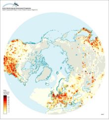
Anthropogenic NOx emissions for 1985 north of 30°N

Anthropogenic NOx emissions for 1985 north of 30°N

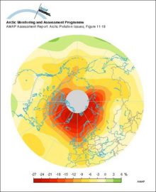
An example of a type 2 ozone anomaly, showing levels of ozone depletion relative to the long-term mean

An example of a type 2 ozone anomaly, showing levels of ozone depletion relative to the long-term mean

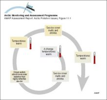
An example of a positive feedback loop Warming leads to a decrease in sea ice cover which in turn leads to a decrease in albedo over the ocean, the result of which is further warming and further decreases in the sea ice cover

An example of a positive feedback loop Warming leads to a decrease in sea ice cover which in turn leads to a decrease in albedo over the ocean, the result of which is further warming and further [..]
An example of a positive feedback loop Warming leads to a decrease in sea ice cover which in turn leads to a decrease in albedo over the ocean, the result of which is further warming and further decreases in the sea ice cover

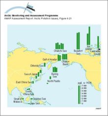
alpha-HCH (ng/L) in seawater: an illustration of the cold condensation effect

alpha-HCH (ng/L) in seawater: an illustration of the cold condensation effect

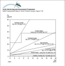
Age accumulation of Hg in liver of polar bears from different Arctic regions

Age accumulation of Hg in liver of polar bears from different Arctic regions

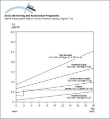
Age accumulation of Cd in liver of polar bears from different Arctic regions

Age accumulation of Cd in liver of polar bears from different Arctic regions

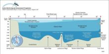
A schematic representation of the three-layer structure of the Arctic Ocean, with the Arctic Surface Layer above the Atlantic Water and Arctic Deep Water The residence time for the different water masses are also shown

A schematic representation of the three-layer structure of the Arctic Ocean, with the Arctic Surface Layer above the Atlantic Water and Arctic Deep Water The residence time for the different water [..]
A schematic representation of the three-layer structure of the Arctic Ocean, with the Arctic Surface Layer above the Atlantic Water and Arctic Deep Water The residence time for the different water masses are also shown

A schematic of the three-level thermodynamic snow ice system model

A schematic of the three-level thermodynamic snow ice system model

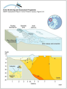
A schematic diagram showing the inflow from the Mackenzie River trapped in the nearshore zone beneath the landfast ice Beyond the stamukhi zone, intermittent opening and refreezing in the flaw lead produces brine which encourages mixing and convection

A schematic diagram showing the inflow from the Mackenzie River trapped in the nearshore zone beneath the landfast ice Beyond the stamukhi zone, intermittent opening and refreezing in the flaw lead [..]
A schematic diagram showing the inflow from the Mackenzie River trapped in the nearshore zone beneath the landfast ice Beyond the stamukhi zone, intermittent opening and refreezing in the flaw lead produces brine which encourages mixing and convection

A comparison of the structures of the Bergen, Toronto, and Combined zonally-averaged global models

A comparison of the structures of the Bergen, Toronto, and Combined zonally-averaged global models

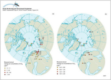
(a) Yearly average sulfur dioxide air concentration measurements in the Arctic, (b) Yearly average sulfate air concentration measurements in the Arctic

(a) Yearly average sulfur dioxide air concentration measurements in the Arctic, (b) Yearly average sulfate air concentration measurements in the Arctic

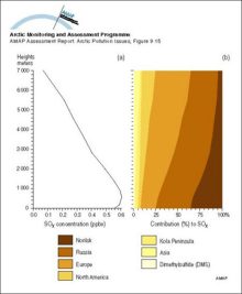
(a) Vertical distribution of SOx (SO2 + SO42-) concentrations averaged over the area north of 75°N, and (b) contributions from the different sources

(a) Vertical distribution of SOx (SO2 + SO42-) concentrations averaged over the area north of 75°N, and (b) contributions from the different sources

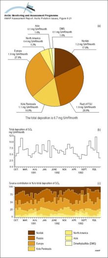
(a) The contribution from the different sources to the total deposition, averaged over the area north of 75°N from October 1990 to May 1994, (b) the calculated total monthly depositions of SOx averaged over the area north of 75°N, and (c) the

(a) The contribution from the different sources to the total deposition, averaged over the area north of 75°N from October 1990 to May 1994, (b) the calculated total monthly depositions of SOx [..]
(a) The contribution from the different sources to the total deposition, averaged over the area north of 75°N from October 1990 to May 1994, (b) the calculated total monthly depositions of SOx averaged over the area north of 75°N, and (c) the

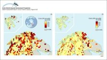
(a) Critical loads of acidity expressed as sulfur (5th percentile presented for each grid) for lakes in northern Fennoscandia and surface waters on Svalbard, and (b) their exceedance (95th percentile)

(a) Critical loads of acidity expressed as sulfur (5th percentile presented for each grid) for lakes in northern Fennoscandia and surface waters on Svalbard, and (b) their exceedance (95th percentile)

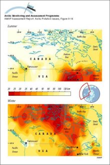
Summer and winter visibility observations (for relative humidities less than 80%) for the period 1951 to 1993 in North America

Summer and winter visibility observations (for relative humidities less than 80%) for the period 1951 to 1993 in North America


Related regions to search:
Number of graphics per country noted in paranthesis

Zoom out     Zoom in