More information and download links below the graphic.
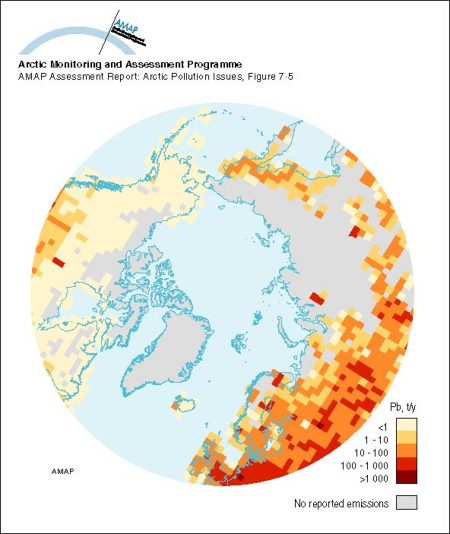
Spatial distribution of emissions of Pb within the 150 km x 150 km EMEP grid system for the area north of latitude 50° N in 1989

Click here, or on the graphic, for full resolution.
Spatial distribution of emissions of Pb within the 150 km x 150 km EMEP grid system for the area north of latitude 50° N in 1989
| Sources | source of data: Norwegian Meteorological Institute, after Pacyna, J.M., B.D. Shin and P. Pacyna, 1993b. Global emissions of lead. Atmospheric Environment Service, Environment Canada, Ottawa. (AAR Figure 7.5) | ||||
|
Cartographer/ Designer |
Data preparation/GIS: Frits Steenhuisen (ACUG); Graphical production: Philippe Rekacewicz and Emmanuelle Bournay (GRID-Arendal) | ||||
| Appears in |
AMAP Assessment Report: Arctic Pollution Issues |
||||
| Published | 1998 | ||||
| Feedback/Comment/Inquiry | Contact webmaster | ||||
| Search for other graphics |
With related subjects Covering the same geographic area |
||||
|
Available Downloads
(please review use constraints above) |
|
||||
|
Citation/Reference Use constraints |
Please refer to the AMAP policy regarding use and reproduction of AMAP maps and graphics |
