More information and download links below the graphic.
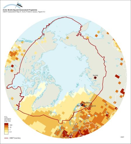
SO2 emissions north of 50°N (modified after Benkovitz et al 1995, see Figure 91) showing point source emissions from Arctic and subarctic non-ferrous smelters and including natural DMS sources from the North Atlantic Ocean Area sources are not included

Click here, or on the graphic, for full resolution.
SO2 emissions north of 50°N (modified after Benkovitz et al 1995, see Figure 91) showing point source emissions from Arctic and subarctic non-ferrous smelters and including natural DMS sources from the North Atlantic Ocean Area sources are not included
| Sources | Title (cont.) for the Asian part of Russia. This emissions data set for 1988 (total inventory of 50 892 900 tonnes S per year) was used as input for modeling transports of sulphur, results of which are shown in Figures 9.11, 9.12 and 9.20. (data source: Norwegian Meteorological Institute). Benkovitz, C.M., T.M. Schultz, J.M. Pacyna, L. Tarrason, J. Dignon, E.C. Voldner, P.A. Spiro, A.L. Jernnifer and T.E. Graedel, 1995. Gridded inventories of anthropogenic emissions of sulfur and nitrogen. J. geophys. Res. 101: 29239. (AAR Figure 9.3) | ||||
|
Cartographer/ Designer |
Data preparation/GIS: David Henry (GRID-Arendal); Graphical production: Philippe Rekacewicz and Emmanuelle Bournay (GRID-Arendal) | ||||
| Appears in |
AMAP Assessment Report: Arctic Pollution Issues |
||||
| Published | 1998 | ||||
| Feedback/Comment/Inquiry | Contact webmaster | ||||
| Search for other graphics |
With related subjects Covering the same geographic area |
||||
|
Available Downloads
(please review use constraints above) |
|
||||
|
Citation/Reference Use constraints |
Please refer to the AMAP policy regarding use and reproduction of AMAP maps and graphics |
