Data format: SDE Feature Class
Coordinate system: Indian_1960_UTM_Zone_48N
Location: Server=mekserv3; Service=5153; Database=mrc; User=sde; Version=sde.DEFAULT
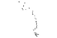
| Monitoring stations for conducting fish migration on the Mekong Mainstream | |
|
|
Data format: SDE Feature Class Coordinate system: Indian_1960_UTM_Zone_48N Location: Server=mekserv3; Service=5153; Database=mrc; User=sde; Version=sde.DEFAULT |
|
Abstract:
Monitoring stations for conducting fish migration on the Mekong Mainstream using local knowledge, 1999 |
|
Metadata elements shown with blue text are defined in the International Organization for Standardization's (ISO) document 19115 Geographic Information - Metadata. Elements shown with green text are defined by ESRI and will be documented as extentions to the ISO 19115. Elements shown with a green asterisk (*) will be automatically updated by ArcCatalog.
No.184, Unit 18, Fa Ngoum Rd., Ban Sithane Neua
No.184, Unit 18, Fa Ngoum Rd., Ban Sithane Neua
No.184, Unit 18, Fa Ngoum Rd., Ban Sithane Neua
Monitoring stations for conducting fish migration on the Mekong Mainstream using local knowledge, 1999
No.184, Unit 18, Fa Ngoum Rd., Ban Sithane Neua
AREA-------------------------

Main stream - Mekong River


DESCRIPTION------------------

point Stations for conducting fish migration survey


SOURCE MAP-------------------

none- coordinates of station were collected using GPS.

SOURCE DATA SET--------------

Field survey done by Fisheries Programme/Assessment of Mekong Fisheries Component (AMFC)

SOURCE AGENCY---------------

MRCS Fisheries programme

GENERATION------------------

location of station: GPS and imported into GIS
information: Field survey using local knowledge.


STATUS----------------------

Last updated:  2000
Completion status:     100 %

DOCUMENTATION---------------

Operator:	Penroong B
Date:		2 October 2003


UNITS-----------------------

Map Units:	meters
System:		UTM, Zone 48, Spheroid Everest
Datum:		Indian 60

FORMAT----------------------

SDE 9.x
Feature type: point

Point Attributes:

SF_B		Survey form No. B (primary key - links to other tables in "Fish Database")
COUNID		Country code as three letters, e.g. CAM
PROVNAME	Province name
DISTNAME	District name
SUBDNAME	Subdistrict name
VILLNAME	Village name
HABNAME		Habitat name
HABCODE		Habitat code
HABDESC		Habitat description
RIVMDIST	Distance to the river mouth
RIVORDER	River order
NORTHING	Northing coordinates(UTM,Zone 48)
EASTING		Easting coordinates (UTM,Zone 48)
GPS_LATV	Latitude of village location, collected from GPS
GPS_LONGV	Longitude of village location, collected from GPS
LATDEG		Latitude in degree
LONGMIN		Longitude in Minute
LONGSEC		Longitude in second
NORTH_SOUTH	North-South direction of migration
LONGDEG		Logitude in degree
LATMIN		Latitude in degree
LATSEC		Latitude in second
EAST_WEST	East-West direction of migration
SUR_DATE	Survey date
No.184, Unit 18, Fa Ngoum Rd., Ban Sithane Neua
Visit http://www.mrcmekong.org