6. Summary of the 2008 country reports
6.2 Lao PDR
General situation
Events in Lao PDR during 2008 were obviously dominated by the August flood conditions on the Mekong mainstream, particularly between Luang Prabang and Vientiane. Though these extreme mainstream flood conditions dominated the picture at the national scale in terms of damage and losses, there were a number of other events across the country which had significant impacts at the local and provincial level. The geography of flooding in the country during 2008 is summarised in Figure 6.2. In this section the flood conditions that occurred across the country other than those of mid August are briefly reviewed, the latter having been considered in detail in Chapter 5.
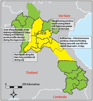
Figure 6.2: Lao PDR – provinces affected
by
flooding and local storms during 2008.
Flooding in Bolikhamxay and Khammouane provinces caused by heavy monsoonal rainfall 17th – 20th June
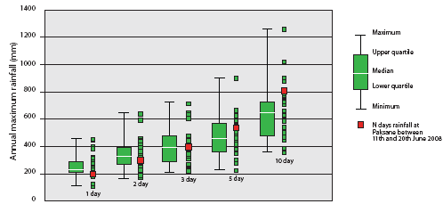
The relatively strong SW Monsoon of 2008 saw the development of sequential periods of intense and prolonged periods of storm rainfall, particularly over the central regions of the country during June. As the figures in the Table 6.2 below show over 800 mm was recorded over the 10 days between the 11th and 20th of the month at Paksane. Although extreme and is amongst the highest that has been observed in the central and southern regions of Lao PDR, this figure has been exceeded several times and by considerable margins as indicated in Figure 6.3. On two occasions more than 1,000 mm has been observed over 10 days; 1,255 mm at Muong Tchepon in 1927 and 1,020 mm at Attapeu in 1996.
June |
Total |
|||||||||
| 11th | 12th | 13th | 14th | 15th | 16th | 17th | 18th | 19th | 20th | |
| 35 | 96 | 110 | 22 | 98 | 102 | 196 | 60 | 83 | 6 | 808 |
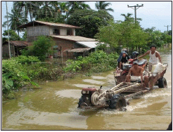
Other than extensive rural flooding the major impact of this period of exceptional rainfall was the flooding of the major road link to the south to a depth of 0.5 m over a distance of 500 metres. This lasted for several days and caused severe disruption to inter-provincial traffic.
Flooding in the Nam Song and Nam Lik Rivers in July
Wide spread heavy rainfalls in mid July in the upper Nam Ngum basin, with a total of more than 300 mm observed on the 18th and 19th at Vang Vieng, caused extensive flooding as the Nam Ngum, Nam Lik and Nam Song rivers rose above critical levels. Flood depths widely exceeded 1m, inundating over 2,000 households in the Kasy, Vang Vieng, Hinheup, Pheuang and Thoulakhom districts. Landslides in the Kasy district caused four deaths.
Figure 6.3: Central
and southern Lao PDR – annual maximum 1, 2, 3, 5, and
10 day rainfalls
observed at 29 sites with a combined total of 680 station-years
of data.
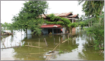
Figure 6.4: Flooding
in the Vang Vieng district of Vientiane province after the
storms of mid July,
with maximum observed rainfalls of more than 300 mm over two
days.
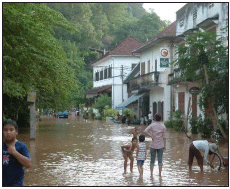
Figure 6.5: Flooding
in Luang Prabang Province as a consequence of the passage
of tropical storm Kammuri in early August.
Flood damage and losses
The major damage and losses were linked to the events of mid August and the passage of tropical storm Kammuri and were centred on Luang Prabang, Vientiane capital, Bolikhamxay and Khammuane provinces. Some 664 villages and 32,610 households were affected, 3 people were killed and 28,500 hectares of rice and other crops damaged. Livestock losses were significant as was damage to national infrastructure, particularly roads, bridges and irrigation systems.
Local flash flooding in the northern and central regions of the country during June, July and September affected 11 districts, 90 villages and 2,500 households and 4 people were killed by landslides. In the agricultural sector 2,250 hectares of crops were damaged and some livestock lost.
The financial loss is currently estimated to be US$56 million, by far the highest figure since systematic damage assessments began in the early 1990s.
Lessons learnt
Given that the August flooding in Vientiane capital and Luang Prabang was the most severe in almost 50 years meant that much was learnt with regard to flood forecasting and emergency response and how the impacts of comparative events in the future might be mitigated.
- Although the short term forecasting over 1 to 2 days was reasonably accurate and provided sufficient time for the implementation of emergency measures such as sandbagging, the accuracy of the medium and longer term forecasts could be improved significantly. Improvements to hydrometric and in particular to the storm rainfall observation network in the northern regions of the country are required in order to
- provide the longer lead times warning of the development of critical conditions within the large northern tributaries such as the Nam Ou. This is particularly relevant as it becomes evident that the satellite images that indicate regional storm rainfall during the passage of tropical storms appear to be providing underestimates and that more ‘ground truthing’ of extreme rainfall is needed.
- Unplanned urban development and the removal of natural flood storage will contribute to increased damages and losses in the future and the issue needs to be addressed.
- The inventory of equipment available to the emergency response agencies needs improvement, particularly with regard to boats and vehicles suitable for accessing and evacuating stricken areas.
Choose a newsletter:
