5. The 2008 flood season
5.1 General observations
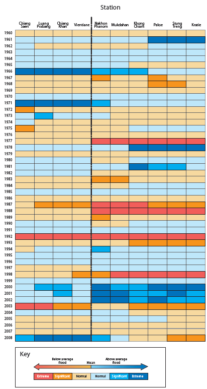
Figure 5.1 The 'historical
geography' of the annual flood on the Mekong
mainstream (1960 – 2008) between Chaing Saen and Kratie.
Flood conditions in the Lower Mekong Basin during 2008 were amongst the most extreme since records began and will be viewed along with those of 1966, 1971, 1978, 2000, 2001 and 2002 as defining the character and magnitude of severe flood conditions on the mainstream. Like the extreme events that have been observed in the past, conditions in 2008 were geographically confined to just a part of the Basin, in this case the areas upstream of Vientiane and Nong Khai. Only in 2001 were exceptional flood conditions basin-wide in any sense. The more typical pattern is for exceptionally high flows to be confined to either the reach upstream or that downstream of Vientiane, which represents a 'hydrological discontinuity'’ between the two. To the north the flood hydrology is determined by flows out of China and the contributions of the large tributaries systems such as the Nam Tha, Nam Ou and Nam Khan. The significance of these inflows then diminishes further downstream as the large left bank tributaries, specifically those in Lao PDR, begin to exert their dominant influence.
This hydrological discontinuity is readily apparent in Figure 5.1 which presents a classification of the annual flood at 10 sites between Chiang Saen and Kratie for the years from 1960 to 2008. The pattern comes about since factors of scale generally preclude weather generating mechanisms, even those at the synoptic scale1 such as tropical cyclones and other intense low pressure systems, from influencing flood runoff over the Basin as a whole. The area of the Basin is many orders of magnitude greater than the area of influence of such weather systems as they pass over it from east to west. Those associated with the large flood events have historically tracked across the region either to the north or south thus bringing about the distinct geographical pattern evident in Figure 5.1.2
The flood of 2008 centred around events during the first half of August when Tropical Storm Kammuri moved across the northern regions of the Lower Basin and the extreme south of Yunnan. In common with most other notable flood seasons there was really only one such weather system which turned what were up to that date fairly average hydrological conditions into those that were exceptional. The point should also be made that 2008 was a strong La Niña year generally associated with enhanced tropical cyclone activity in the western Pacific.
Conditions further south in the Basin were very much below average, with peak water levels and discharges at Kratie and further downstream pointing to a relatively weak SW Monsoon.
_____________
2 Synoptic scale refers to migratory weather systems with a horizontal dimension greater than 1,000 km, such as tropical cyclones. 2This geographical pattern is discussed in further detail in the Annual Mekong flood report 2006 on pages 11 to 13
Choose a newsletter:
