6. Thailand 2007 country report
6.1 General Situation
Flood conditions in the northern Thai Mekong region in the Kam and Kok Rivers were less serious than those of 2006. As in Lao PDR the principal cause of flood damage and loss was Tropical Storm Lekima in October, which mainly affected the Mun -Chi River Basin. In Loei province a flash flood occurred on the 9th September, killing four people There was significant damage to property, including houses and schools, and 600 persons had to be evacuated. Locally floodwater was reported to be up to five metres deep.
6.2 Tropical Storm 'Lekima'
The southern parts of the Mun and Chi River Basins around Nakon Phanom, Kalasin Mukdahan, Roi Et Yasothon and Ubonrachatani were the most affected by the storm rainfall associated with 'Lekima'. Most rainfall occurred on the 4th and 5th of October, by which time the event had been downgraded to a tropical depression. Rainfall decreased from in excess of 250 mm in the east of the Mun-Chi Basin to less that 150 mm in the west during the first week of October as the intensity of the system decreased as it tracked westwards. In some areas the short duration storm bursts produced some of the highest rainfall ever recorded over a few hours. Flash flood conditions occurred in the Nam Pong, Lam Choen Rivers and upper Nam Mun, where the topography is steeper.

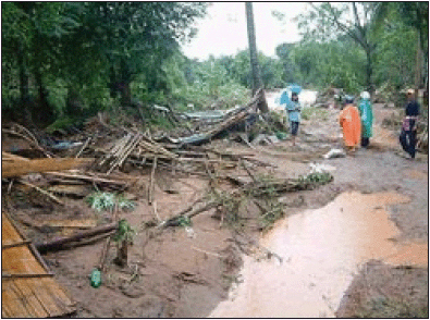
Figure 41. The remains of three
houses destroyed by the 9th September
flash flood in Loei. Three residents were lost.![]()
6.3 Damage and impacts
Flooding in northeast and central Thailand during October 2007 was described by the Bangkok Post as the worst in 40 years, with troops and rescue workers dispatched to assist stranded residents. A number of people died as a result of being swept away and thousands of hectares of crop lands were inundated to a depth of 1 m and more. There was widespread disruption of road links and many communities were cut off. Other reports suggest that the total number of people killed was as high as 67 and that 17,000 people had to be evacuated.
6.4 Lessons learnt
The number of people killed by flash floods in Thailand each year underscores the ongoing difficulty of providing adequate warning. The need for flood risk mapping and land use zoning such that residential property is not constructed on land at risk needs higher priority. Such floods have the power to change the courses of rivers and streams and bury property in sediment and mud, which often arises from landslides into the river channel during the course of the event. While torrential rain on already saturated catchments is key to the onset of flash flooding, the drainage and topography of the surrounding area determines the scale and impact of the event. Losses from flash floods, including related hazards such as landslides and debris flows, appear to be increasing due to pressure on land resources. There is also widespread agreement that under global warming storm rainfall intensities will increase. The location, type and value of human activities that appear to be expanding into more hazardous areas needs to be reassessed on the basis of a better understanding of the flash flood phenomenon and the areas at risk. The approach should be based upon:
- risk identification, using flood mapping;
- vulnerability identification and building designs to reduce it;
- the implementation of mechanisms that ensure effective
warnings and emergency
response at the local scale.
Choose a newsletter: