Navigation Programme
Improving navigation in the Mekong and its tributaries can boost tade and local economies throughout the basin, thus playing an important role in poverty alleviation. International navigation is one of the most important mandates of large river commissions. The Mekong Navigation Programme (NAP) analyses river transport systems and related activities in the Lower Mekong Basin, covering a network of 8,500 km of waterways. Within the basin both maritime shipping and inland water transport (IWT) play significant roles in livelihoods and economic growth as direct access.
Both of these sectors remain under-utilised and rather inefficient in terms of management: waterways could be used far more for transport and offer great advantages in terms of economic and environmental costs. Since the inception of the programme considerable advances have been made in enabling the use of the Mekong and its tributaries as transport and freight routes.
The MRC Navigation Programme combats poverty and helps its Member States to achieve the Millennium Development Goals by creating the opportunities to:
- Reduce shipping accidents
- Promote the potential of Mekong shipping for cargo and for tourism;
- Establish legal navigation frameworks between the countries;
- Transport the agricultural produce of remote farmers;
- Reduce transport costs;
- Facilitate public-private partnerships;
- Improve the waterways for navigation;
- Increase direct and trickle-down job opportunities.
The Navigation Programme Project Implementation Plan, which includes a selection of projects to fit the Belgian financial contribution to the NAP 2006-2010 was formulated and approved by the MRC Member Countries. At the request of the Navigation Advisory Body, this exercise involved needs assessments on improving Mekong navigation, identification and selection of projects through appraisal missions, plus consultation visits and national workshops between November 2006 and February 2007. The process was concluded with a regional workshop in Ho Chi Minh City in March 2007. The Navigation Advisory Body, which frees the MRC Joint Committee from deciding on technical matters, consists of three high-ranking transport representatives from each Member State and representatives from the MRCS. The body held its second meeting in March 2007 and its third in January 2008.
A number of navigation projects started in 2007, and some have already been successfully concluded. Amongst these is the project on Hydrodynamic and Morphological Impacts of Channel Dredging in the Tonle Sap Lake, completed in July, with a regional workshop held in September to finalise reporting. Initial results showed that if a narrow channel were dredged it would probably not require much maintenance and would therefore be stable. Dredging a year-round access route to Siem Reap would provide a major breakthrough for both tourism and trade, though a thorough environmental imapct assessment will be required before any dredging is carried out.

In March and June, following detailed legal study and initial draft of a new Agreement between Cambodia and Viet Nam, the Navigation Programme facilitated two meetings in Phnom Penh for implementation of the Agreement on Cross-border Waterway Transportation. Both Cambodia and Viet Nam are eager to formulate and implement this agreement, which will facilitate trade and transport between the countries and encourage traders from other nations to come to their ports. To improve understanding on how other navigation agreements have been established, high ranking officials from Cambodia, the Lao PDR, Thailand and Viet Nam participated in a working visit to Belgium and the Netherlands. This trip also addressed issues of capacity building within implementation of the agreement for cross-border navigation.
The river stretch between Luang Prabang and Vientiane is quite difficult for navigation and only a handful of pilots able to negotiate the rapids. The MRC will make this route more accessible by introducing detailed river charts, engineering designs, and installing channel markers in danger areas. Tendering for the Condition Survey of Dangerous Areas for Navigation (hot spots) between Luang Prabang and Pakse in the Lao PDR and in Thailand started in October 2007. For the Mekong stretch downstream of Luang Prabang, terms of reference for a study that will provide legal framework recommendations for cross-border navigation between the Lao PDR and Thailand have also been developed.
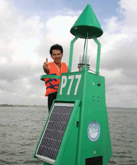
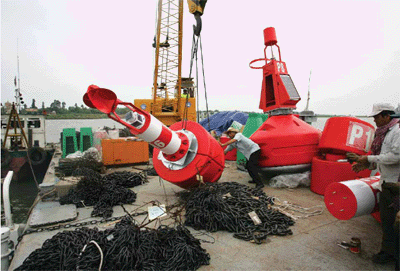
The MRC project on Procurement, Installation and Training on Aids to Navigation on the Mekong between Phnom Penh Port and the Cambodia-Viet Nam border was completed in 2007. This initiative installed 56 buoys and eight fixed structures, making safe day and night navigation possible on this stretch for the first time. The next step will be to install similar navigation aids along the stretches between Luang Prabang and Pakse in the Lao PDR and Thailand, and between the Cambodia-Viet Nam border to the sea. The Development of the Management Information System for Phnom Penh Port, Phase I Project (implemented in 2006) has been completed and is now fully operational. This work has increased the efficiency of port operation, enhanced communication systems and improved competitiveness.
As a follow-up to the Eleventh Dialogue Meeting, the MRC Navigation Programme will cooperate with the Navigational Affairs Bureau of Yunnan, China. The prospects for this dialogue developing into a fruitful partnership are good, as concrete plans have been approved by both partners. Following a formulation mission, planned for January 2008, implementation of cooperation projects should start in the first half of 2008. The areas of proposed cooperation are joint surveys, detailed channel design for navitgation safety, and pollution control.
Choose a newsletter: