Age structure of Alaska indigenous, Alaska total, and United States total populations, 1980

Age structure of Alaska indigenous, Alaska total, and United States total populations, 1980

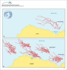
(a) Trajectories of five satellite-tracked buoys launched in Mackenzie Bay, Canada, and (b) results of 30-day trajectories of oil launched from five hypothetical spill locations in the Beaufort Sea

(a) Trajectories of five satellite-tracked buoys launched in Mackenzie Bay, Canada, and (b) results of 30-day trajectories of oil launched from five hypothetical spill locations in the Beaufort Sea

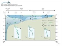
The different domains of the Bering Sea continental shelf are separated by fronts The coastal domain (depth <50m) tends to be vertically homogeneous, the middle domain (50-100m) shows a clear two-layered structure, while the outer domain (100-170m)

The different domains of the Bering Sea continental shelf are separated by fronts The coastal domain (depth <50m) tends to be vertically homogeneous, the middle domain (50-100m) shows a clear [..]
The different domains of the Bering Sea continental shelf are separated by fronts The coastal domain (depth <50m) tends to be vertically homogeneous, the middle domain (50-100m) shows a clear two-layered structure, while the outer domain (100-170m)

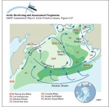
Schematic diagram of circulation and the extent of different water masses in the Bering Sea

Schematic diagram of circulation and the extent of different water masses in the Bering Sea


Related regions to search:
Number of graphics per country noted in paranthesis

Zoom out     Zoom in